In this episode of 80 Days: An Exploration Podcast, we’re exploring the story behind the writer of the most well-known secular Christmas song: Jingle Bells, and some of its surprising backstory. We also reflect on whether AI will replace Luke, Mark or Joe first, and take on the now-traditional festive quiz where Luke tests how much trivia from our back-catalogue we can recall. From all of us, have a very merry festive season, and we’ll see you in 2026.
Thanks to all our patrons who support the show. We really appreciate your continued backing of us. If you want to join them, more information is available at www.patreon.com/80dayspodcast
The coversheet of One Horse Open Sleigh, by James Lord Pierpont, the original title of Jingle Bells (photo from Wikimedia Commons – Public Domain)
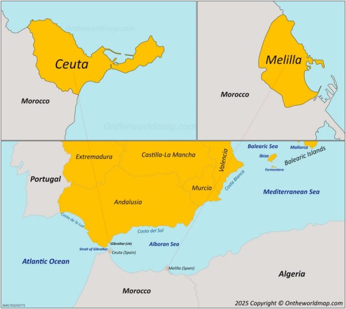
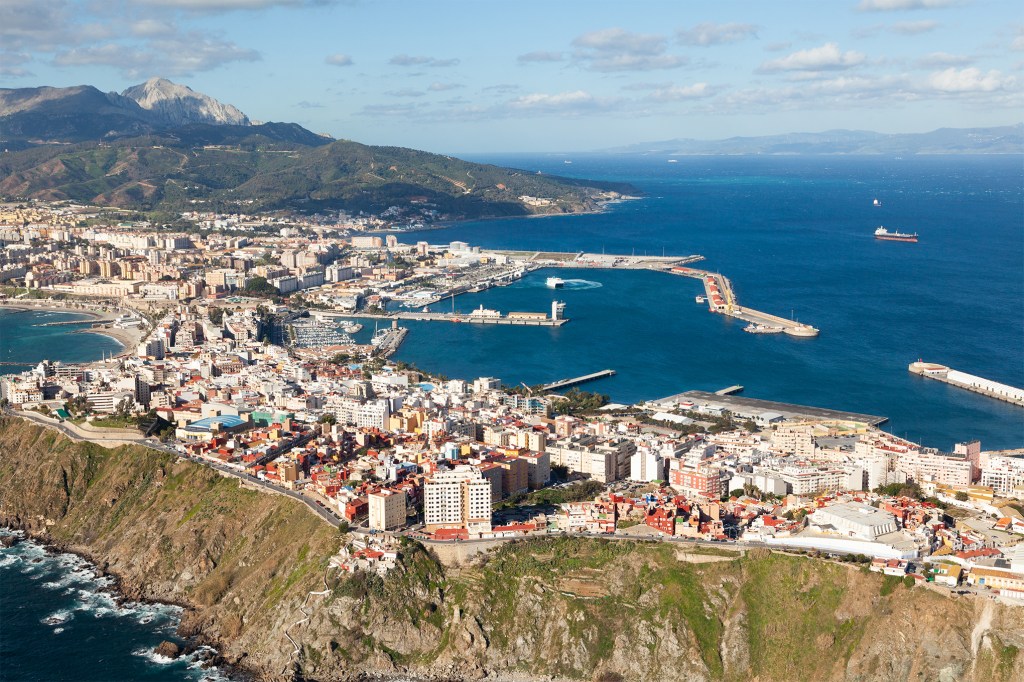
In this episode of 80 Days: An Exploration Podcast we’ll be talking about the autonomous city of Ceuta — Spanish exclave, military post, and free port on the coast of Morocco, at the Mediterranean entrance to the Strait of Gibraltar. Ceuta, Melilla (also an exclave), and other tiny islets along the coast of North Africa constitute the territories of Spanish North Africa. The city is on a narrow isthmus that connects Mount Hacho (also held by Spain) to the mainland. Mount Hacho has been identified as possibly the southern Pillar of Heracles, of the ancient Mediterranean world. Ceuta was controlled by the Muslim Umayyad Dynasty up to 1415, and then changed hands a number of times over the 15th and 16th Centuries. It played an important role in the Spanish Civil War, and gained its modern autonomous status in 1995. Ceuta’s land area is only about 18.5 square kilometres or 7 square miles, making it among the smallest places we’ve ever talked about,and has a population of around 80,000, similar to Andorra, the Isle of Man or the US Virgin Islands.
The climate here is warm but moderated by the straits, with mean annual temperatures of 18 °C (65 °F) with average highs of 21 °C (70 °F) and lows of 15 °C (60 °F). The currency is the Euro, and the language is Spanish, with a strong Arabic presence.
Ceuta and Melilla are the only piece of EU territory on mainland Africa – a political and legal reality that has never been recognised by Morocco, which claims both territories to this day.
Fun Fact – Western Sahara was a previously-Patreon-backed finale episode. You guys just have a real hankering for contentious North African territories, don’t you?
As we mention in the episode, this (somewhat delayed) finale to season 6 was voted on by our Patreon backers, and thanks as always to all of them for their support. You can sign up to Patreon to get a say in the episodes we cover in the seasons to come.
This BBC Explainer on the status of Ceuta and Melilla is a good starting point for beginners. The BBC also has a useful factsheet.
This CNN feature headlined “Inside the tiny corner of Spain that lies in the middle of North Africa” is another useful primer.
History blog “A Small Part of History” has a lengthy post about the conquest of Ceuta by Portugal.
For a more visceral look at the city, this video travel guide of Ceuta from Travel Obscurer is worth checking out.
One of the many books we referenced in this episode was Europe or Africa? : a contemporary study of the Spanish North African enclaves of Ceuta and Melila by Peter Gold. It’s available on Archive.org.
We also spoke about Count Julian, whose Wikipedia page is well worth perusing.
Mark lent on A.R. Disney’s A History of Portugal and the Portuguese Empire – From Beginnings to 1807 for his section. You can find an excerpt here.
Another useful read was The Spanish Exclaves in Morocco by Robert Rézette, which is available on Google Books.
The UK’s National Maritime Museum has a whole page dedicated to Cueta in the Napoleonic Wars.
The UNHCR report on Anti-Muslim Hatred and Discrimination in Ceuta we mentioned is available here.
The substantial page on Wikipedia dedicated to the border fence is here. More can be found in World of Walls: The Structure, Roles and Effectiveness of Separation Barriers by Said Saddiki which is available online here.
On Franco and the Spanish Civil War, worth a read is The Crescent and the Dagger: Representations of the Moorish Other during the Spanish Civil War by Elisabeth Bolorinos Allard, available here.
Some of the music used in the episode includes:
The anthem of Ceuta, which is featured in the final music break
Thanks to all our patrons who support the show. We really appreciate your continued backing of us. If you want to join them, more information is available at www.patreon.com/80dayspodcast
In this episode of 80 Days: An Exploration Podcast we’ll be talking about Shetland, a group of about 100 islands, fewer than 20 of them inhabited, in Scotland, 210 km (130 miles) north of the Scottish mainland, at the northern extremity of the United Kingdom, around 340km or 210 miles from Norway. The islands total around 1,500 km2 (or 560 sq mi), making them similar in size to the nearby Faroe Islands [recommend listening to this past episode], American Samoa or Gran Canaria.
Among the settlements on Mainland, the largest island, is Scalloway, a fishing port. Lerwick, also on Mainland, is the islands’ largest town and commercial and administrative centre. The early history of the islands is dominated by the influence of the Vikings, who settled here in the 9th Century. From the 14th century, it was incorporated into the Kingdom of Scotland, and later into the United Kingdom. The climate is generally windy, cloudy and often wet, with rain falling on more than 250 days a year, and average low temperatures a little above 1 °C (34 °F) in winter and around 14 °C (57 °F) in summer.
Shetland is as far north as St Petersburg, Russia, or Anchorage, Alaska, which makes the islands an ideal place to watch the northern lights, or as they’re known locally the ‘mirrie dancers’ while in summer there is almost perpetual daylight, a state of affairs known locally as the “simmer dim”.
We had a guest on the podcast this episode, local writer, tour-guide and podcasters Laurie Goodlad, who can be found on shetlandwithlaurie.com. Thanks to Laurie for her great contributions to helping us understand Shetland, only a fraction of which is included in the episode – if you’ve fallen in love with Shetland, much more can be found in her blog and podcast episodes.
A Shetland pony photographed by Ronnie Robertson (CC-BY)The Prince of Wales set off a trend of Fair Isle jumpers, part of a general inter-war Northern Isles boost in knitting and garment industry
BBC “In Our Time” episode on the Orkneyinga Saga, which touches on Shetland (despite focussing on the Earls of the nearby Orkneys); there is no saga specifically about Shetland
Shetland Times has an article about Thomas Johnson, ancestor of the author Louis Mackey, who tells the tale of how he was press ganged by Rear Admiral Edward Thornborough and lost his legs in a battle in the Bay of Biscay, and his life after return
Thanks to all our patrons who support the show. We really appreciate your continued backing of us. If you want to join them, more information is available at www.patreon.com/80dayspodcast
In this episode of 80 Days: An Exploration Podcast, we’re exploring (in the format of festive trivia and quizzes) winter celebrations from around the world, and diving into our back-catalogue to test our memories of explorations past. Grab a cup of cocoa or egg nogg and enjoy! From all of us, have a very merry festive season, and we’ll see you in 2023.
Thanks to all our patrons who support the show. We really appreciate your continued backing of us. If you want to join them, more information is available at www.patreon.com/80dayspodcast
In this episode of 80 Days: An Exploration Podcast we’ll be talking about Socotra, an island in the Indian Ocean, lying between the Gulf of Aden and the Arabian Sea. It lies 380 kilometres (205 nautical miles) south of the Arabian Peninsula and 240 kilometres (130 nautical miles) east of Somalia. Geographically part of Africa, it has historically been an extremely isolated island due to the monsoon winds that make it difficult to reach for large parts of the year. This isolation has resulted in unique plant and animal life, with the island harbouring many species which went extinct elsewhere tens of thousands of years ago, and It has been described as “the most alien-looking place on Earth” Over its history, the island has seen influence from Ethiopian Christians, Greeks, Arabs, Portuguese Explorers and the British East India Company, among others, and as a result has a unique blend of cultures and languages. The island is 3,796 km2 (1,466 sq mi) in size, making it similar in land area to the US state of Rhode Island, or slightly larger than Luxembourg. Around 50,000 people today call Socotra home, with the principal city, Hadibu, boasting around a fifth of the total population. The island became a part of Yemen in 1967, and has recently been impacted by ongoing conflict caused by the Yemeni Civil War, which began in 2014 and is ongoing as we record this. In 2008, Socotra was recognised as a UNESCO World Heritage Site for its unique flora and fauna. The islanders rub noses when they are introduced, and primarily speak Soqotri, an ancient Semitic language, which has up to a hundred words to describe a goat.
Thanks to all our patrons who support the show. We really appreciate your continued backing of us. If you want to join them, more information is available at www.patreon.com/80dayspodcast
In this episode of 80 Days: An Exploration Podcast we’ll be talking about the Central American country Belize, formerly known as British Honduras. This small country on the Yucatan Peninsula. It is bordered by Mexico to the north, the Caribbean Sea to the east, and Guatemala to the west and south. This region was a stronghold of the Maya Heartland from around 1500BC up to the arrival of Europeans, namely the Spanish, in the 1600s. A tussle between Spain and Britain developed in subsequent decades, and Belize became a British colony in 1840, and a Crown colony in 1862, before achieving full independence in 1981. The country has an area of 22,970 square kilometres (8,867 sq mi) and a population of just over 410,000, making it similar in size to Wales, Djibouti or the US state of New Jersey, but the least densely populated nation in Central America. This is a very diverse place, ecologically, culturally and linguistically. The official language is English, but there are many other communities such as Maya, Garifuna, Creoles and even Mennonites, who speak a variety of tongues. Belize has over 400 islands or Cays off its coastline, as well as one of the world’s largest marine sinkholes, the Blue Hole, which is 318 m (1,043 ft) across and extends to a depth of 124 m (407 ft). The country also boasts the second largest barrier reef in the world after the one everyone’s heard of in Australia.
Thanks to all our patrons who support the show. We really appreciate your continued backing of us. If you want to join them, more information is available at www.patreon.com/80dayspodcast
In this episode of 80 Days: An Exploration Podcast we’ll be talking about Wellington, New Zealand. Located at the south end of the country’s North Island, Wellington is the third largest city, and capital of New Zealand. Māori oral tradition tells that Kupe discovered and explored the region in about the 10th century, before Maori people settled the country from around 1280, making New Zealand the world’s last major landmass to be occupied by humans. Maori named the natural harbour that forms here named the harbour Te Whanganui-a-Tara. As they tend to do, Europeans eventually showed up and began to colonise, in this case in the 1830s, inevitably coming into conflict with the Maori, and eventually renaming the settlement for Sir Arthur Wellesley, hero of Waterloo. Wellington was declared a city in 1840, and was chosen to be the capital city of New Zealand in 1865, making it the world’s southernmost capital of a sovereign state. Today, Wellington is home to around 420,000 people, giving it a similar population to Oakland, California or Manchester, England. It is well-known for its coffee culture, its natural beauty, its booming film industry and its extreme winds. Wellington is the world’s windiest city, with an average wind speed of 27 km/h (17 mph)
We also had a huge amount of help from Thomas Rillstone for this episode. He’s the legend behind the History of Aotearoa New Zealand Podcast. You should check out his show for far more info on New Zealand than we could ever hope to know, and for much more accurate pronunciations than we could ever manage.
Some further reading material is provided below:
We referred a number of times in this episode to the official government site on Wellington’s history, which you can find here.
Another great source is the Wellington Museum. Did we mention there’s a lot written down in this one? The episode was well over three hours before it was edited!
There’s also an episode of Absolute History all about the history of the city, which touches on some of the points we made and also gives a good tour around the city. Featuring Peter Jackson!
Thanks to all our patrons who support the show. We really appreciate your continued backing of us. If you want to join them, more information is available at www.patreon.com/80dayspodcast
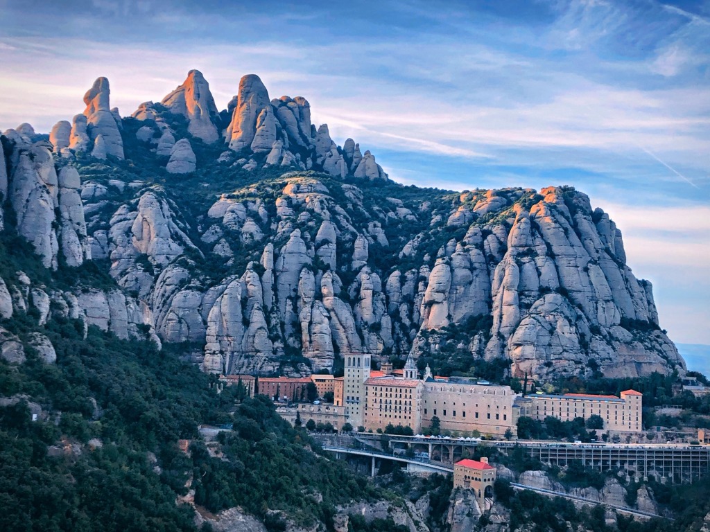
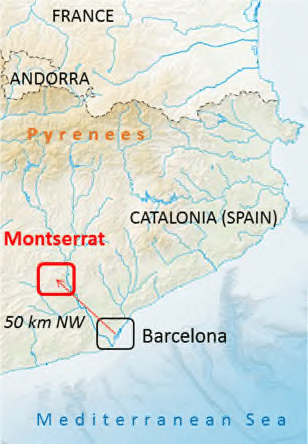
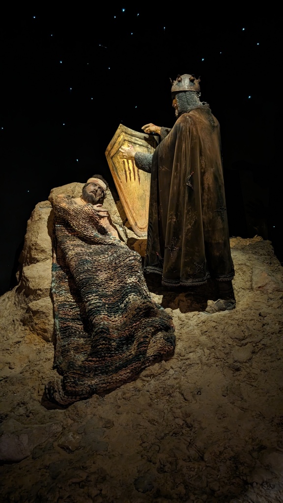
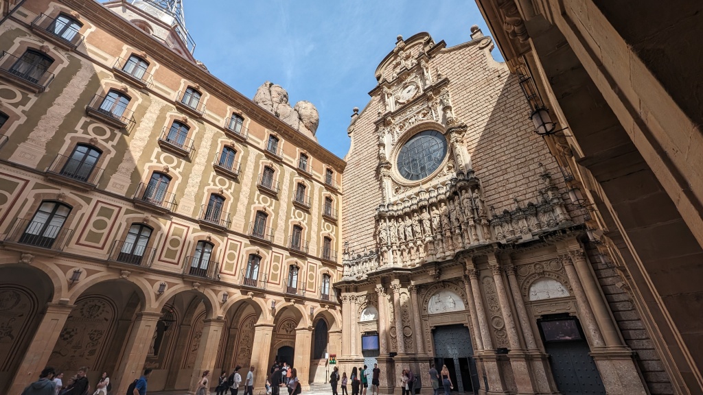
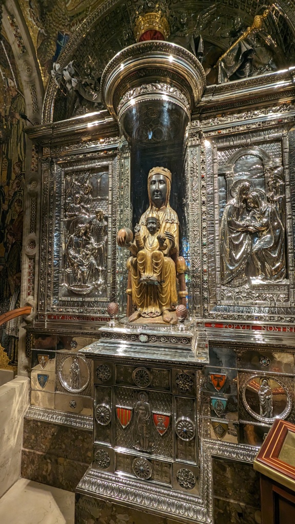
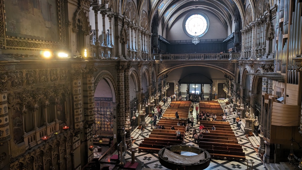
In this episode of 80 Days: An Exploration Podcast we’ll be talking about Montserrat in Catalonia, Spain, a spectacular mountain range not far from Barcelona. Montserrat was “Montserrat” literally means “serrated mountain” in Catalan, and the name accurately describes its bizarre and unique aspect with a multitude of jagged rock formations that are visible from a great distance. This spot is best known today for the Benedictine Monastery Santa Maria de Montserrat, located about 45 km northwest of Barcelona, and the the statue of the Virgin Mary within that lends its name to the monastery, which has its own unique story to tell. Montserrat has been of significance for centuries, bearing witness to Catalan and Spanish history from its lofty mount and even becoming entwined in some of the most decisive conflicts to have swept across the Iberian Peninsula since the Monastery was founded in 1025, including the Napeolonic wars and the brutal fighting pre and post the Spanish Civil War. In terms of poulation, there are less than 100 monks who make their permanent home here, but up to two million tourists flock here each year to scale the mountain and take in the history and legacy of the monastery, including quite recently, two of the co-hosts of this episode.
Virolai, the Catalan Anthemm performed by Escolania de Montserrat
Thanks to all our patrons who support the show. We really appreciate your continued backing of us. If you want to join them, more information is available at www.patreon.com/80dayspodcast
In this episode of 80 Days: An Exploration Podcast we’ll be talking about Åland, an autonomous and demilitarized archipelago of Finland, which lies between Finland and Sweden, although it is closer to the latter by around 20km. Åland (which can also be spelled Aaland) is the smallest region of Finland by both area (1,580 km2 or 610 sq mi) and population (30,000), constituting around half a percent of Finland’s land area and half a percent of its population. Despite being Finnish, the only official language is Swedish and the capital city is Mariehamn. Aaland is made up of around 6,700 islands, making it one of the world’s largest archipelagos.
Since the end of WWI, Åland has been politically neutral and entirely demilitarised, and residents are exempt from conscription to the Finnish Defence Forces.
Fasta Åland or Main Åland is the largest island in the group and accounts for more than 70 percent of the total land area and is home to about 90 percent of the archipelago’s population, as well as the capital Mariehamn. In terms of land area, Aaland is comparable to the Faroe Islands, American Samoa, Guam, Oahu (Hawaii). Out of approximately 6,500 islands, 65 are inhabited with several connected through causeways and bridges. The rest are linked by ferries and private boats.
Åland’s original name was in the Proto-Norse language Ahvaland. Proto-Germanic ahwō is related to the Latin word for water, aqua. In Swedish, this first developed into Áland and eventually into Åland, literally ‘river land’—even though rivers are not a prominent feature of Åland’s geography. For reasons I’m sure we’ll get to, almost all the houses, and pretty much all the roads, are red. There are also roughly as many deers here as there are people.
If you’re curious about the tourism industry on Aland, check out visitaland.com.
The article “CLAY FIGURINES FROM THE ALAND ISLANDS AND MAINLAND FINLAND” can be found here, and further info on Funnel Beaker Culture is available here.
A handbook on the History of Finland is here, containing some extensive info on Aland.
The recording on Svea Jannson’s “Who Can Sail Without Wind” is here on Wikipedia.
You can find Oolanin Sota (the Finnish Crimean war song) on YouTube.
Thanks to all our patrons who support the show. We really appreciate your continued backing of us. If you want to join them, more information is available at www.patreon.com/80dayspodcast
In this episode of 80 Days: An Exploration Podcast, we’ll be talking about Burkina Faso (formerly the French Upper Volta), a landlocked country in West Africa bordered by Mali to the northwest, Niger to the northeast, Benin to the southeast, Togo and Ghana to the south, and Côte d’Ivoire to the southwest. As of 2021, the country had an estimated population of just over 20,000,000. Total land area is around 274,000 km² (or roughly 106,000 sq mi), making it slightly smaller than Italy, slightly larger than New Zealand or the US state of Colorado. Burkina Faso has a primarily tropical climate with two very distinct seasons, wet and dry. Its northern regions are in the Sahel, making them very dry and arid, while the more southern regions are cooler and more tropical.
The Mossi people, which still dominates the country today, moved into the region around 1100, and still makes up around 50% of the ethnic population. These were a tribal, agrarian society with a love of horses. Other important ethnic groups include include Fulani 8.4%, Gurma 7%, Bobo 4.9%, Gurunsi 4.6% Senufo 4.5%, Bissa 3.7%, Lobi 2.4%, Dagara 2.4%, Tuareg/Ikelan 1.9%, Dioula 0.8% (percentages of modern population). In 1896, it was colonized by the French as part of French West Africa; in 1958, a new nation named Upper Volta became a self-governing colony within the French Community. In 1960, it gained full independence with Maurice Yaméogo as president. However, since then the country has struggled to maintain political stability, with political coups or uprisings taking place in 1966, 1980, 1982, 1983, 1987, and twice in 2022.
The nation is quite poor, and is one of the world’s least-economically developed, with around 75% of people to this day living off subsistence agriculture. Burkinabe farmers are well-known for working to music, usually drums. Burkina Faso is also one of the youngest countries in the world, thanks to very high fertility (Women have on average 5 children each) and a low average life expectancy, which currently stands at just under 60, among the lowest in the world. The median age is only around 17, and this has caused a massive spike in population over the past half-century, as yearly population growth rate is more than double the world average.
The “griot” class in Mossi society are called the Bend Naaba, which transmits historical data and the head chief at Ouagadougou is called the the Moro-Naba or Mogho Naba. The legendary ancestor of the Mossi chiefs is the warrior princess Yennega (UNESCO biography).
A good starting point for learning about traditional masks in Burkinabe cultures is the Wikipedia article on Art of Burkina Faso, and various museum archives, such as Princeton
Boukary Koutou, also known as Wobgho, the Mossi King of Ouagadougou with his personal escort of Mossi cavalry, Burkina Faso. From “Du Niger au Golfe de Guinée par le pays de Kong et le Mossi” by Binger, Louis Gustave, 1892, page 35, illustrated by Édouard Riou.The Grand Mosque of Bobo-Dioulasso, Burkina Faso by JamesA (Wikimedia Commons)
Thanks to all our patrons who support the show. We really appreciate your continued backing of us. If you want to join them, more information is available at www.patreon.com/80dayspodcast


.jpg)